Mammoth Lakes is one of the Eastern Sierra's most popular recreation destinations, prized for its excellent skiing in the winter, ample hiking opportunities in the summer, and world-class scenery. Few visitors today realize that the town's roots trace back to a late-1800s gold mining boom, which faded away by the 1930s. Although few traces of the old mines and mills still remain, some remnants can be found hidden in the forests in the Lake Mary area. Visitors hiking the short trail to Heart Lake walk right past the remains of the Mammoth Consolidated Mine, the last major mine to operate in the area, often surprised to find a large well-preserved mine camp hidden in the trees.
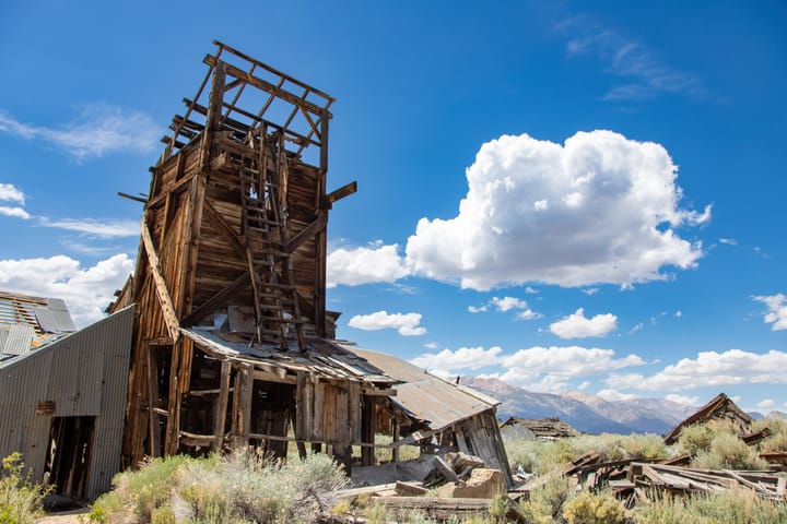
The remains of the mine camp, mines, and mill buildings have been preserved in a state of arrested decay (similar to Bodie) by the Inyo National Forest Mammoth Ranger District, the Southern Mono Historical Society, and the Town of Mammoth Lakes. A 1/2-mile self-guided loop trail explores the various aspects of the mine operation.
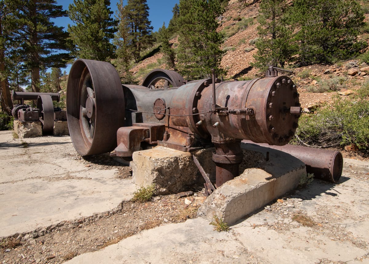
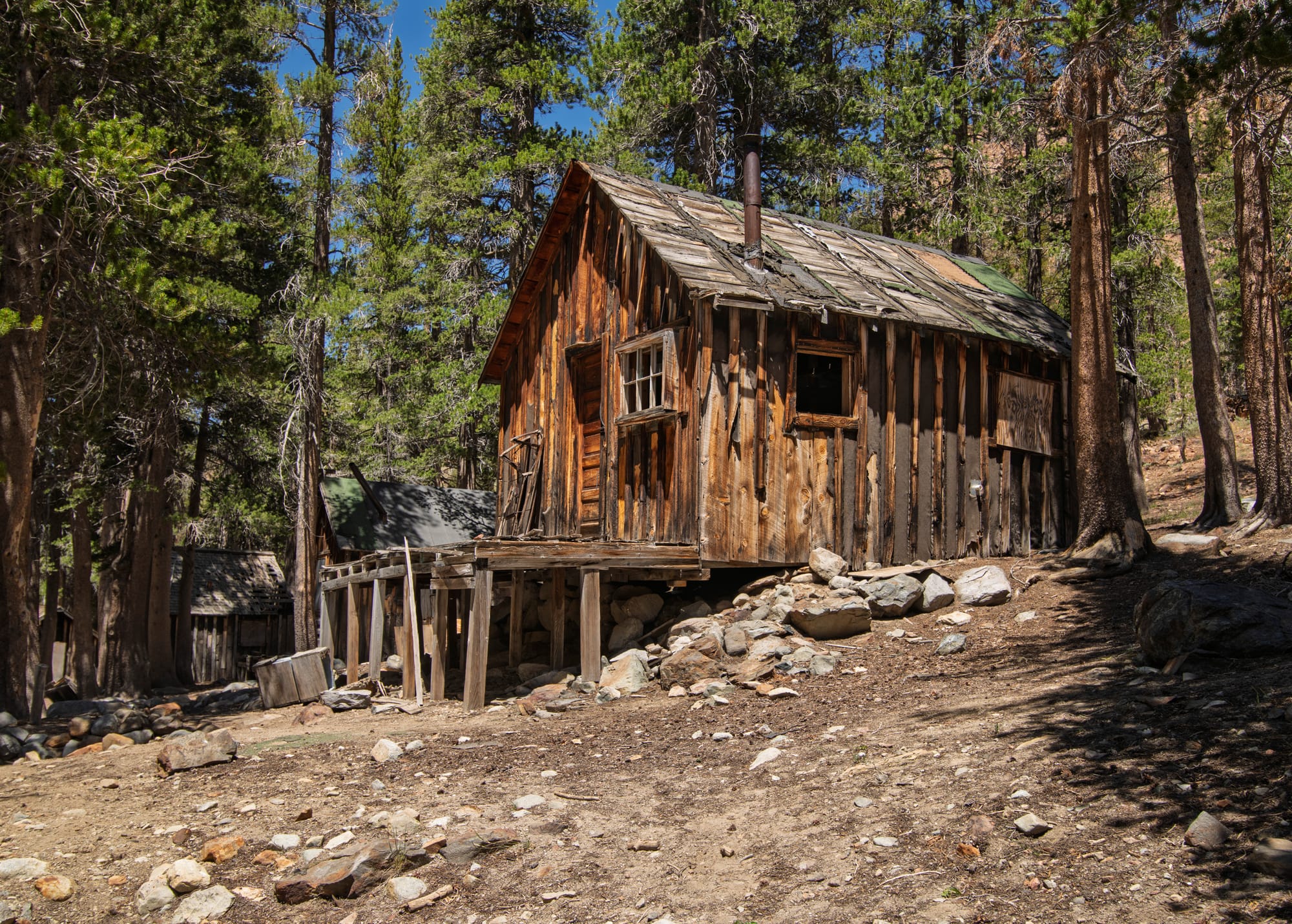
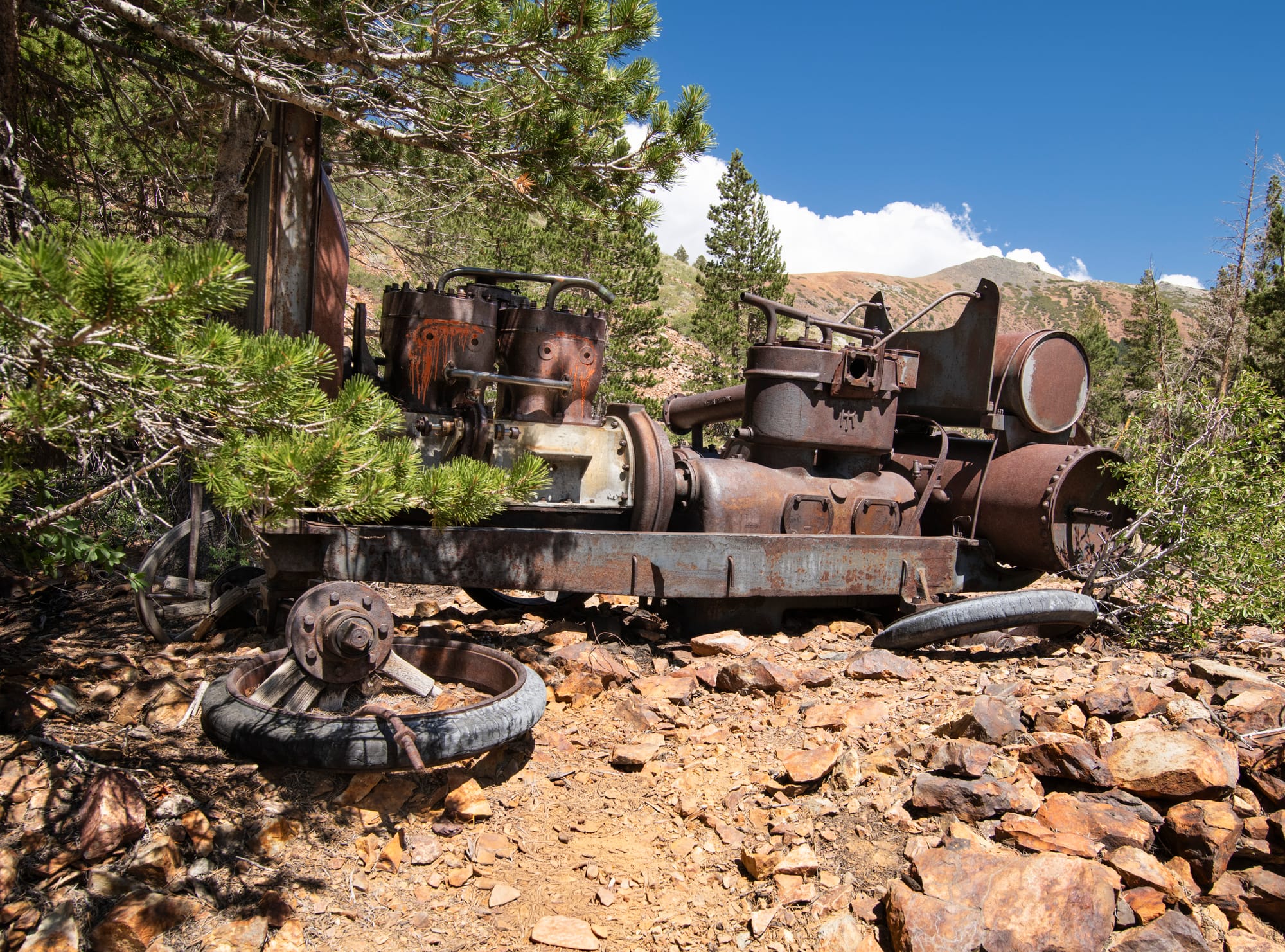
Although this site may lack the thrill and "wilderness experience" of hiking to a remote mine deep in the mountains, it is nonetheless an enjoyable and worthwhile experience. Highlights include several well-preserved historic cabins (some with furnishings still visible inside), some rare and impressive machinery, and scenic views from the upper mine workings. The short hike is family-friendly, well suited for kids or people unable to hike long distances or climb mountains. Kids love this place, making it a good way to introduce them to mining history.
History
Prospectors first discovered gold on the western slope of Mineral Hill in June 1877. (Mineral Hill, today aptly named Red Mountain, is the prominent ridge which towers above the eastern shore of Lake Mary.) Numerous claims were filed along the ridge, leading to the formation of the Lake Mining District. By 1879, four towns boasting hundreds of citizens had sprung up: Mammoth City, Mineral Park, Mill City, and Pine City. Major mines included the Mammoth, the Headlight, the Monte Cristo, and further the south, the Lisbon.
Despite the early fervor, the boom neither lasted long nor produced the expected bonanza. The mines and towns began to decline as early as 1880, and by 1890 most of the residents were gone and only intermittent activity was taking place.
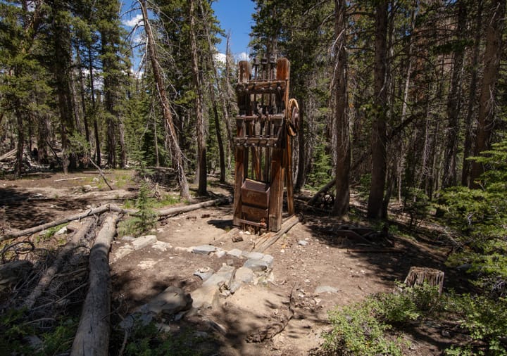
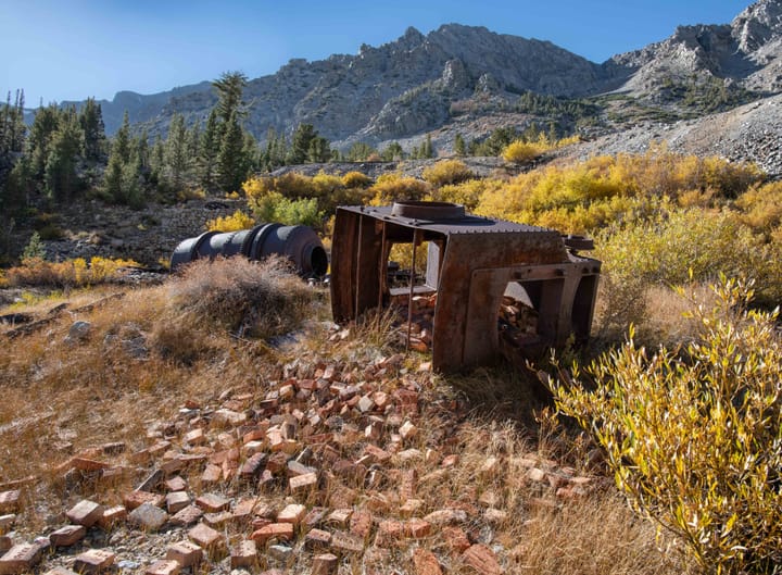
A new era began in 1927 when A.G Mahan and his son Arch acquired several old claims south of Lake Mary, formed the Mammoth Consolidated Mining Company, and began building a mine camp. The camp eventually consisted of several employee cabins, a generator house, a cookhouse, a mine office, the Superintendents House, Arch Mahan's summer cabin, and a pump house. Near the camp lay an assay office, a blacksmith shop, and an ore-processing mill. Just up the hill were two mine tunnels and an air compressor building.
The mine operated full-time until 1933, when the Great Depression and bank failures led to financial difficulties. Lessees intermittently worked the mine until the 1980s, when the Mahan family regained control of the property and subsequently donated the buildings and equipment to the town of Mammoth Lakes. (The land is part of the Inyo National Forest.)
Directions
Getting There
From Hwy 395, drive west on Hwy 203 into Mammoth Lakes (Hwy 203 becomes Main Street once in town.) At the major intersection with Minaret Road, 3.7 miles from Hwy 395, continue straight ahead toward Lake Mary on Lake Mary Road. In another 3.6 miles you will approach the east shore of Lake Mary; turn left onto Around-Lake-Mary Road. After 0.6 miles, turn left onto Coldwater Campground Road, and continue 0.7 miles, through Coldwater Campground, to the parking lot at the end of the road. The parking lot is a one-way loop, with the Heart Lake/Mammoth Consolidated Mine trailhead at the far (north) end. (Note that all the roads in the Lake Mary area can be very busy in the summer, and the trailhead parking lot may fill on weekends.)
The Hike
Hike: Easy, 0.4 mile loop, 80 ft gain. 1 hour.
From the northeast corner of the parking lot, start out on the signed Heart Lake Trail. Cross the small wooden bridge which crosses Mammoth Creek; you will see an information board just ahead. From that board, the cabins at the Mammoth Consolidated Mine Camp will be visible through the trees to the north. A loop trail around the mine site begins shortly after the information board; see the map below.
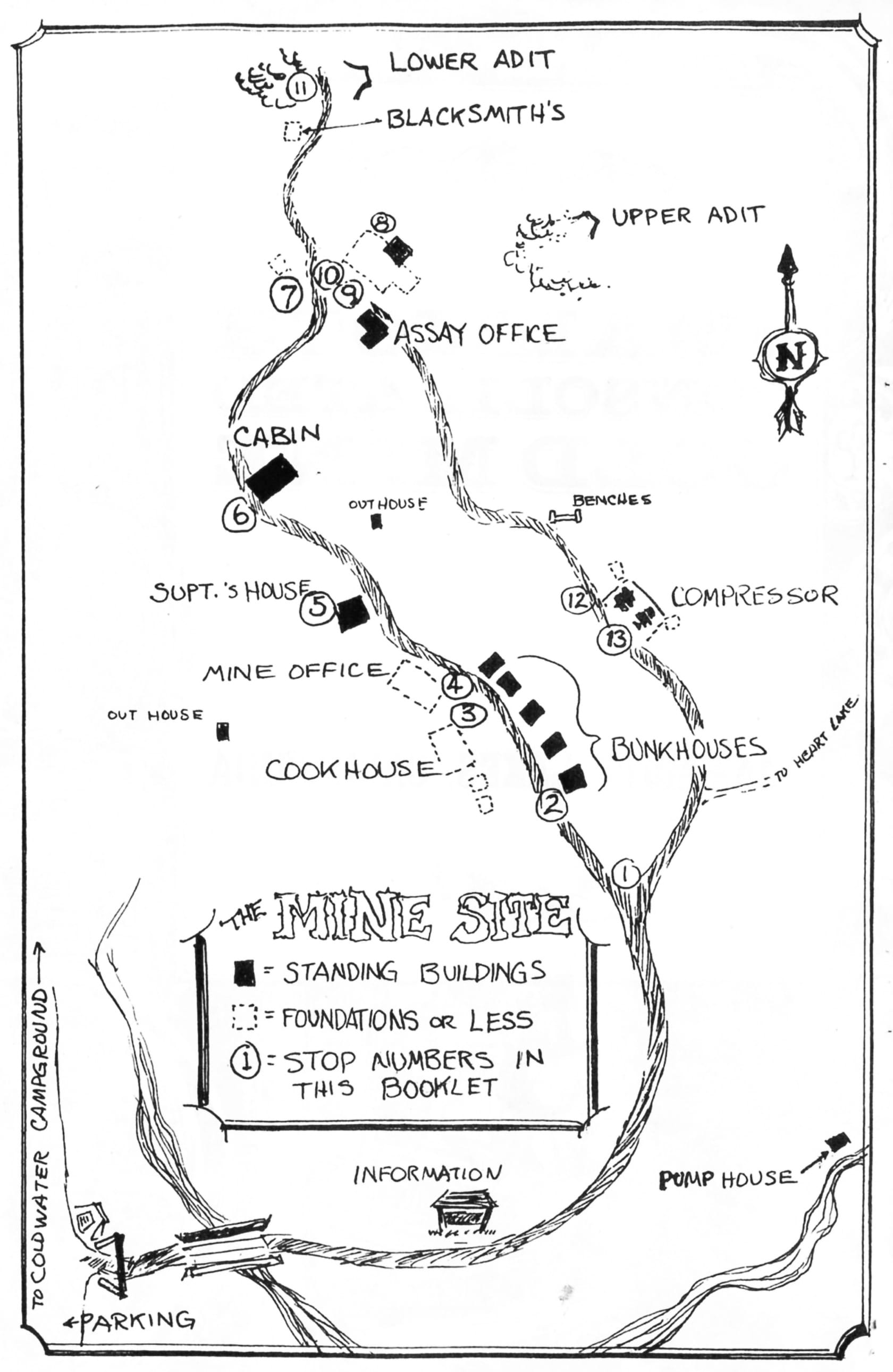
This map was included in a Forest Service brochure about the mine site, which is no longer in print. The brochure is very handy to carry along on the hike, as it also contains information about each numbered stop on the hike (the stops are no longer numbered).
You can download a PDF copy of the brochure here:
The recommended route is to follow the loop clockwise, as shown on the map. Start at the miners' cabins, then visit the ruins of the Superintendent's House and Mahan Cabin, then drop down to the mill ruins and assay office. The minimal remains of the blacksmith shop are just north of the mill. From near the assay office, follow a short trail up to the Lower Adit. (On a hot day, the gated portal is a welcome relief!) Return to the main loop trail, then look for a trail up to the Compressor House ruins and the Upper Adit. The most impressive machinery is at the Compressor House; the gated Upper Adit is just beyond. The view from the adit is worth the short walk.
GPS Waypoint
- Heart Lake Trailhead: 37.59123°, -118.98921°